About me

I am a Ph.D. student in GIScience and Cartography at the University of Iowa, with a passion for Geographic Information Science, Geospatial Data Analysis, Network Analysis, Human Geography, and GeoEthics. My current research focuses on analyzing kinship networks and migration regions in the U.S., using family tree datasets and historical census data to better understand migration patterns over the settlement period and how they affect and are affected by kinship networks. In addition to my work on migration, I have published research papers in other areas, including groundwater vulnerability and risk assessment. I have presented my research at various conferences and am always looking for opportunities to collaborate with others in the field.

Portfolio

Story Map

As part of the NSF-funded BluGAP project, I developed the “Rivers and Risks” interactive story map to bridge the gap between spatial analysts and watershed communities and foster collaboration in river protection.

Skills: Geospatial Analysis, Map Design, Cartography, Visual storytelling.

Tools: ArcGIS Pro, ArcGIS Online, ArcGIS StoryMaps, ArcGIS Survey123.

Animated Map

Animated map that illustrates Iowa’s changing population density over time, highlighting the gradual shift from river-dominated landscapes to those shaped by railroads (dotted black lines) and major roads (solid black lines).

Code and data are available at  https://github.com/Maryamtd/BlueGap2024 

Skills: Web Mapping, Geovisualization, Spatial Analysis.

Tools: D3.js, JavaScript & HTML & CSS.

Spatial-Social Network

Using network community detection methods, I mapped and analyzed social connections across various topics within a spatial environment.

Mapping migration regions and their evolution from population-scale family trees.

The effect of disruptive events on spatial and social interactions.

Skills: Network Analysis, Spatial Data Analysis, Social Networks, Academic Writing, Academic Presentation.

Geocoding (Toponym Resolution)

First Paper Award Winner at the CaGIS+UCGIS 2024 Conference. Developed a multi-step framework to resolve birthplace fields for over 25 million records in crowd-sourced genealogical data.

A Hierarchical Approach for Geocoding Birthplaces in Temporally Continuous Crowd-Sourced Family Tree Data.

[Complete code, results, and data will be available with the final version of the under-review paper.]

Skills: Big Data Analysis, Data Cleaning, Relational Database Management, AI Validation, Project Management.

Tools: Python, PostgreSQL and PostGIS.

Observable Projects

https://geog3540.github.io/Maryam-Torkashvand

This collection showcases a variety of mapping techniques, including choropleth, proportional symbol, bivariate map, and flow map. These maps are built in Observable, with a focus on geovisualization.

Skills: Geovisualization, Map Design, Cartography, Data collection.

Tools: D3.js, Observable, Flow Mapper.

Web Mapping

Interactive maps that include small multiple maps illustrating variable patterns in Florida, and a comparison of community detection algorithms for identifying migration regions in the U.S.

Skills: Web Mapping, Network Analysis, Spatial Analysis, Usability Testing.

Tools: Python, D3.js, JavaScript & HTML & CSS, Google Survey.

Groundwater Vulnerability and Risk Assessment

Integrated GIS modeling with various decision-making and optimization techniques to assess groundwater vulnerability and risk in different aquifers.

Paper 1, Paper 2, Paper 3

Skills: GIS Modeling, Multi-Criteria Decision Making, Optimization, Statistics, Academic Writing.

Tools: ArcMap, MATLAB, SPSS.

Spatio-temporal dynamics

In the NSF-funded I-GUIDE Summer School, we explored the connection between countries, regions, and continents in merchandise and service trades before and after the COVID-19 pandemic.

Presenting the work as a session in the I-GUIDE Virtual Consulting Office.

Skills: Network Analysis, Geoethics, Team Work.

Tools: R, I-GUIDE Platform.

Mapping Temporal Regions

Developing and evaluating two solutions for automating the mapping of changes in spatial communities using Python programming.

https://github.com/geog3050/torkashvand/tree/main/project

Skills: Network Analysis, Spatial Analysis, Geo-programming.

Tools: Python, Geopandas.

Publications

Google Scholar

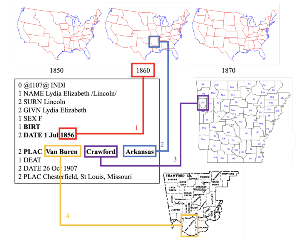
Torkashvand, M., & Koylu, C. (2024, June). A Hierarchical Approach for Geocoding Birthplaces in Temporally Continuous Crowd-Sourced Family Tree Data. CAGIS+ UCGIS Symposium 2024.

Torkashvand, M., Neshat A, Javadi S, Yousefi H, Berndtsson R. (2023) Groundwater Vulnerability to Nitrate Contamination from Fertilizers Using Modified DRASTIC Frameworks. Water, 15(17):3134. https://doi.org/10.3390/w15173134.

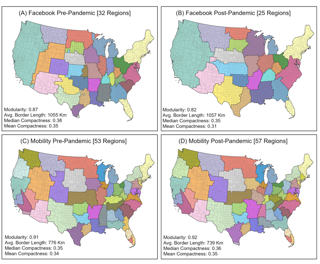
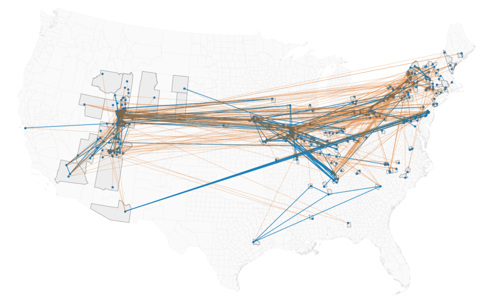
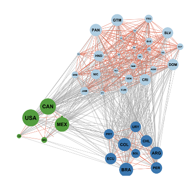
Koylu, C. & Torkashvand, M. (2023) The effect of disruptive events on spatial and social interactions: An assessment of structural changes in pre-and post-COVID-19 pandemic networks. GIScience 2023 Workshop on Disruptive Movement Analysis (DMA’23), September 12, 2023, Leeds, United Kingdom. https://doi.org/10.48550/arXiv.2311.01559.

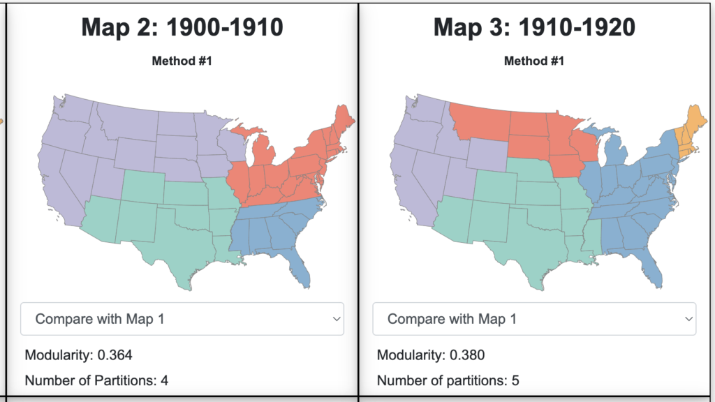
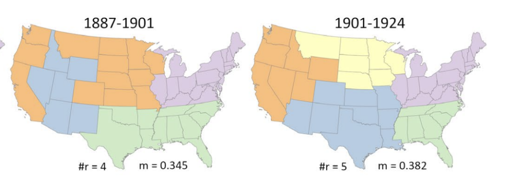
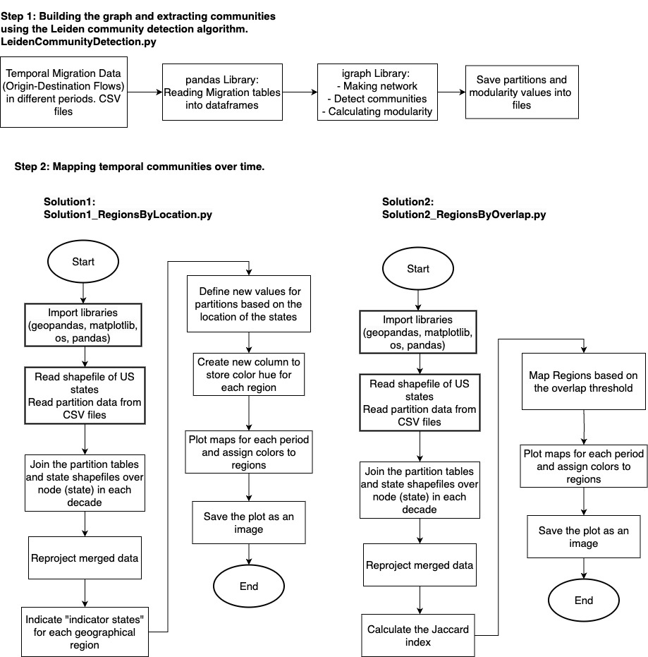
Koylu, C., Torkashvand, M., Kwon, H., Kasakoff, A. B. (2022) Mapping migration regions and their evolution from population-scale family trees: What can they tell us about cultural identities and regions today? In 6th ACM SIGSPATIAL Workshop on Geospatial Humanities (GeoHumanities’22), November 1, 2022, Seattle, WA, USA. https://doi.org/10.1145/3557919.3565814.

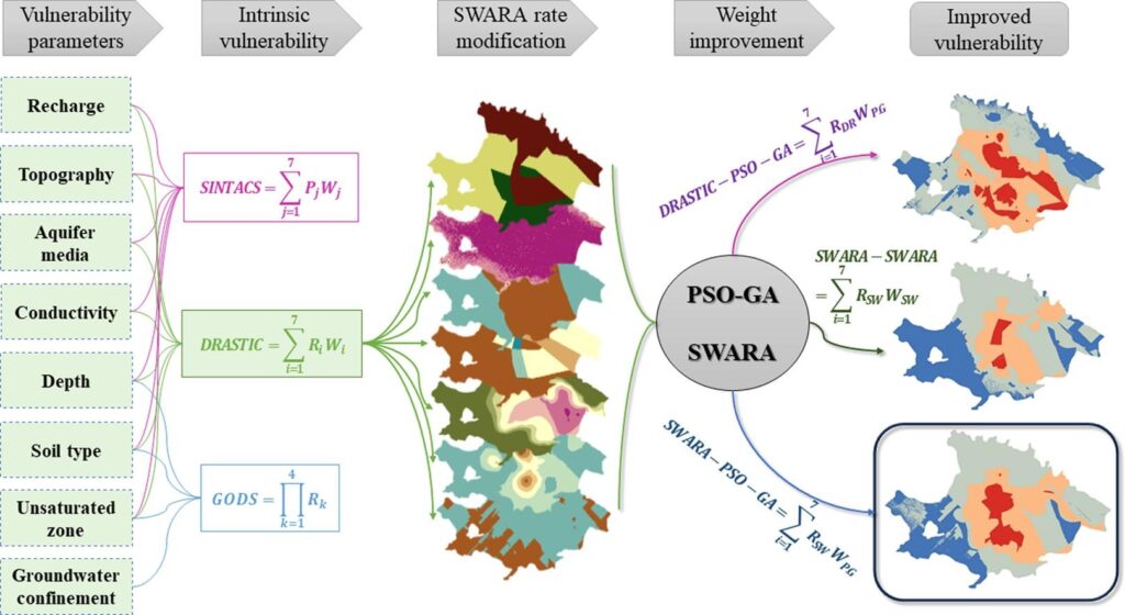
Torkashvand, M., Neshat, A., Javadi, S., Pradhan, B. (2021) New hybrid evolutionary algorithm for optimizing index-based groundwater vulnerability assessment method. Journal of Hydrology, 598, 126446. https://doi.org/10.1016/j.jhydrol.2021.126446.

Torkashvand, M., Neshat A., Javadi S., Yousefi H. (2021) Improvement of GIS-Based DRASTIC Model Using Step-Wise Weight Assessment Ratio Analysis (SWARA) and Two New Hybrid Frameworks (Iran). In: Ksibi M. et al. (eds) Recent Advances in Environmental Science from the Euro-Mediterranean and Surrounding Regions (2nd Edition). EMCEI 2019. Environmental Science and Engineering. Springer, Cham. https://doi.org/10.1007/978-3-030-51210-1_283.

Torkashvand, M., Neshat, A., Javadi, S., Yousefi, H. (2020) DRASTIC framework improvement using Step-wise Weight Assessment Ratio Analysis (SWARA) and combination of Genetic Algorithm and Entropy. Environmental Science and Pollution Research. https://doi.org/10.1007/s11356-020-11406-7.